Exploring Spatial Data Science


We inhabit a world where spatial data are increasingly at our fingertips, whether that be location-based services via mobile phones; or growing data volumes from satellites revolutionising monitoring environmental change. The challenge is how we extract information ethically and efficiently from these diverse spatial data sources, particularly as Earth system data become increasingly volumetric.
Our research
We are living in a new age of spatial information with an ever increasing array of data sources and volumes at our fingertips, ranging from location-based services via mobile phones and low-cost sensors, to Earth observation satellite data. Environmental systems data and models are becoming increasingly multifaceted– revealing new insights about where we live and life around us, the energy we use, the geology below our feet, the deep oceans, and exchanges between air, land and sea. The challenges in extracting information from these diverse spatial data sources are significant. DEES researchers draw on a unique combination of expertise in machine learning, AI, remote sensing, visualization and geographical information science to find ethical and efficient solutions to these challenges.
View a breakdown of outputs from research work within this theme
Research Stories
Click here for more recent stories relating to research in this theme
European Space Agency (ESA) Climate Office funds €2m ocean carbon research
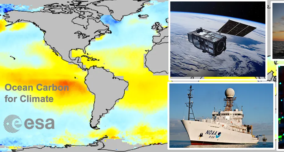
Professor Jamie Shutler (PI) and Dr Dan Ford, with help from Dr Jenny Watts, have been awarded a new project by the European Space Agency (ESA) Climate Office – a project called Ocean Carbon for Climate. This two-year project, worth €0.9 million, is led by Jamie’s team (Centre for Geography and Environmental Science) and involves partners from Europe and the US (Columbia University, Institute Pierre Simon Laplace, Alfred Wegener Institute, VLIZ in Belgium, Plymouth Marine Laboratory, Heriot Watt University and SpaceConnexions). It aims to initiate ESA activities towards a longer-term generation of ocean carbon climate data records from satellite data to support annual global carbon budget assessments, the Intergovernmental Panel on Climate Change and the Paris Climate agreement. A sister project (ESA Satellite based observations of Carbon in the Ocean: Pools, fluxes and Exchanges, SCOPE) has also been funded. This second project, also for two years, is led by Plymouth Marine Laboratory, is worth €1.1 Million, and also includes Jamie Shutler (as Co-I) and Dan Ford. This second project aims to develop the first 4D global ocean carbon budget from satellite data and machine learning.
Remote sensing in the department of Earth and Environmental Sciences
Research groups
Work within this theme is focused around the Centre for Environmental Mathematics, which is located within our department. We also work closely with the Institute of Data Science and Artificial Intelligence.